Faced with the threat of rising sea levels and extreme weather events, Rimini is rethinking its waterfront: green infrastructure, new sewage strategies and nature-based solutions to protect the territory and community
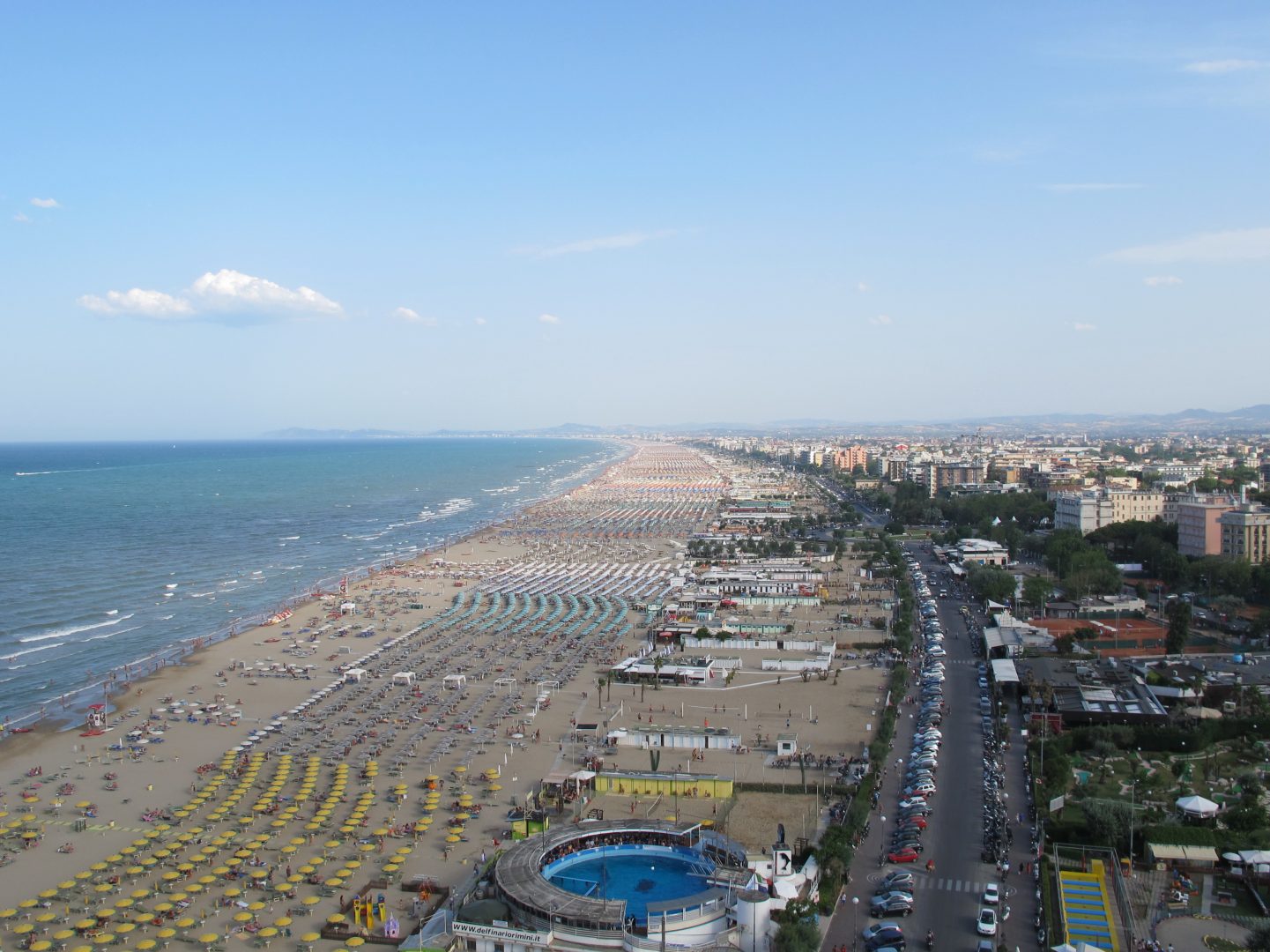
The silhouette of the Ferris wheel on the dock looms in the background. A few steps away is the iconic Grand Hotel, made famous by Federico Fellini, facing the sea and the beach with its umbrellas and lounge chairs. The air is filled with the scent of piadina and sunscreen. We are on Lungomare Tintori, the first stretch of the seaside promenade that winds along the southern coast of Rimini, the capital of summer tourism in Romagna. In fact, our feet stand on a highly sophisticated technological complex, designed to respond to two consequences of the climate crisis we are experiencing: rising sea levels and the increased frequency of extreme events, which in recent years in Romagna have led to disastrous floods and inundations
Rising sea levels are one of the most serious consequences of the climate crisis. It is obviously not limited to the Adriatic coast, on the contrary. A report, published last year by the European Environment Agency, quantifies the phenomenon, and the resulting picture is far from reassuring. It estimates an average global rise of at least twenty centimeters from the early 1900s to today, with the problem accelerating since the 1960s. Depending on the climate scenarios – or rather on our ability to contain, in the coming decades, the emissions that affect the climate – the average relative rise in sea levels is estimated to be between 30-55 centimeters (low-emission scenario) and 63-102 centimeters (high-emission scenario).
Naturally, there are many variations, even though the level has risen in almost all European coastal regions. While the northern coasts of the Baltic regions and Norway are somewhat less exposed, the situation is much more problematic for the Netherlands, for many deltas and estuaries and for all the coasts of southern Europe.
For example, as noted by our colleague Marco Ranocchiari in his report on the Danube Delta, today the great river carries only a third of the sediment it once did. The sediment is retained by the numerous dams built over the last century, the ongoing dredging of the canal, and, finally, the rising sea level.
This latter phenomenon, although widely studied in recent years, is still only partially understood. The causes are multiple: the melting of glaciers, both continental and polar, the thermal expansion of the oceans due to rising temperatures, land use, its overbuilding and intense exploitation, for example around ports and canals, and the subsidence of many areas between land and water.
Rising water levels mean increased short- and long-term risks. Data from the European Environment Agency spares no one. A ten-centimeter rise in sea level can lead to up to three times the frequency of coastal flooding. Based on current knowledge, by 2050, that is, within 20-25 years, the frequency of extreme events related to sea level rise could increase tenfold in many European coastal areas.
Increasingly intense storms mean increased coastal erosion and reduced natural protection for beaches and dunes. In other words, a net loss of territory, with a retreat of the so-called coastline, a phenomenon quantified in the Mediterranean at between fifty centimeters and one meter over the last thirty years.
Therefore, adaptation plans and actions would be necessary to protect millions of people living along the coasts from direct impacts, such as the disastrous effects of floods – which involve the risk of loss of human lives and destruction of houses and infrastructure – but also from indirect ones, such as the salinization of aquifers and coastal lands, the spread of pathogens, as well as the increased anxiety and psychological stress associated with insecurity.
In a previous analysis on the consequences of the floods in Romagna, specifically in Faenza, we also observed how the disruption to daily life, uncertainty and fear had a very heavy psychological impact on many people, and one that was perhaps not considered enough in the post-emergency management phase.
The situation on the Romagna Riviera
A 2020 study from the University of Bologna found that in the period 1993-2019 sea level rise was just under three millimeters per year: a figure which, although consistent with other studies, is worrying considering the specific conditions of the area. The article states that the Emilia-Romagna coastline is “extremely sensitive to coastal flooding due to storm surges and sea-level rise”. The analysis is based on two types of data: those from three tide gauges and those from the Copernicus Maritime Service, the European agency for satellite observation of our planet.
In addition to rising sea levels due to the climate crisis, other factors also contribute to the critical situation in the region: “subsidence, sediment supply deficit due to the marked decrease in fluvial transport, removal of the dune ridge and increased anthropic pressure”.
Local officials at various levels have been aware of these concerns for some time now. In a document prepared for European Maritime Day 2022, Luisa Perini, a geologist in the Land Protection Sector, points put that as much as 47% of Emilia-Romagna’s coastal zone is affected by erosion. Seaking of the human pressure highlighted by researchers at the University of Bologna, according to data presented by the Region through 2022, urbanization has increased by 400% since the Second World War. One of the reasons for this, on the Romagna Riviera, is the significant increase in tourism, especially seaside tourism, which accounts for approximately 11% of the region’s gross domestic product.
Another 2022 research led by Mattia Amodio from the Euro-Mediterranean Center on Climate Change (CMCC) analysed the cost-benefit ratio of protecting this stretch of Adriatic coast from sea level rise. The study used the current state of the art knowledge to create scenarios for 2050 and 2100. In the first scenario, by 2050, the projected average rise in the Adriatic Sea level is approximately 0.2 meters compared to the historical 1970-2004 period, while in the second scenario, by 2100, the rise is projected to be between 0.5 and 0.7 meters. In the first case, if nothing is done, the sea could completely wash away Rimini's beach from the port dock to the south , while in the second case, the water could penetrate hundreds of meters from the coast , considering that precisely because of the aforementioned subsidence, part of the hinterland is practically already below current sea level.
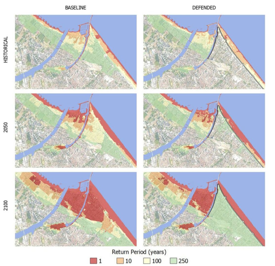
Extent of the Rimini area affected by floods with and without waterfront protection measures. (Image from: Amadio, M., Essenfelder, AH, Bagli, S., Marzi, S., Mazzoli, P., Mysiak, J., and Roberts, S.: Cost–benefit analysis of coastal flood defense measures in the North Adriatic Sea, Nat. Hazards Earth Syst. Sci., 22, p. 265-286, 2022.)
Trying to outline feasible strategies to protect the Adriatic coast was the focus of the AdriaClim project, a collaboration between Italy and Croatia, which concluded in 2023 with the recommendation of urgent measures for more careful coastal management, freeing up a significant portion of it to act as a buffer, returning space to the sea and rebalancing the flow of sediment.
Among the priorities that emerged from the various studies there is also the regeneration of waterfronts,, by renovating beaches and strengthening their defense systems. This does not mean, however, building fixed barriers, as has been widely hypothesized in past decades.
Already in 2010, a study conducted by a Rimini-based research institute, the CSASpa Group, in collaboration with the Municipality of Rimini, analysed the effects of different types of barriers, varying in rigidity and segmentation, built since the 1940s to combat coastal erosion. These structures, similar to those found in many other contexts since the second half of the last century, have undoubtedly protected certain stretches of coastline, encouraging greater sediment accumulation on beaches. However, they have exacerbated the problem in adjacent, unprotected areas, creating a sort of fragmentation of the coastal context. Therefore, for at least fifteen years now, we have been discussing more integrated protection mechanisms that do not interfere with the natural dynamics of the coast.
The effects of fixed barriers are clearly visible in many different contexts. For example, in the Danube Delta, as noted in the aforementioned report by Marco Ranocchiari.
The Rimini waterfront project completed in the last decade is different and presents itself as a potential solution, more suited to the changes underway. So let us return to that waterfront, to that technological complex we are walking on, which combines hydraulic engineering and nature-based solutions.
A few years ago, when the City Council considered renovating the southern seafront’ directly east of the city’s historic center, it sought to address ecological issues.
“The Sea Park is a project that began in the fall of 2019 and is completely redesigning our coastline”, explains Anna Montini, an economist at the University of Bologna and councilor for ecological transition for the City of Rimini. “It essentially involves a very important green infrastructure for cycling and pedestrians that has replaced a completely paved driveway, making the overall surface much more permeable”.
A promenade, where people can walk, cycle or use other soft transportation, was built at an average elevation of 285 centimeters above sea level, one meter higher than before the work began: an adequate defense against sea level rise for the coming decades. Elevation that, as explained by Montini, “was assessed based on scientific data that took into account both forecasts of sea level rise and the effects of subsidence, as well as extreme weather events in the worst-case scenarios, such as strong winds blowing against the coast, rough seas and high tides”.
But Rimini did not stop there. The project is complemented by a Bathing Protection Plan, which includes a renovation of the city’s sewer system. “There are about twelve basins in the city”, adds Montini, “and in eight of these basins we have completely separated the networks, thus moving from a mixed network system to one where the white networks are separated from the black ones, which always work according to the purification principle”. In the remaining four basins, the largest in the city, massive storage, first rain, and retention tanks have been built.
While work is still underway on the remaining basins, the completed system is connected to three one-kilometer pipelines that run under the seabed. “Each of these three pipelines has a diameter of two meters”, continues Montini, “so in the case of a meteorological event that exceeds the capacity of the two basins, a total of 39 thousand cubic meters, we can push the excess water through a system of very modern and powerful pumps one kilometer from the shore, making the city more hydraulically safe and therefore greatly reducing the risk of flooding and inundation”.
Taken as a whole, the Rimini waterfront regeneration project has created a much more livable environment. “Using so-called nature-based solutions, the coastline has been renaturalized, with the reconstruction of a system of sand dunes and the planting of plants and trees between the beach and the walkway”, sums up Montini. “By doing so, the redevelopment was made more harmonious, and we also created shaded areas that allow people to stroll and enjoy the seafront even on hot days, thus making this stretch of coast much more livable for everyone”.
This result seems to have convinced even many of those who were initially skeptical: those who had raised doubts and controversies, such as tourism operators and hoteliers along the waterfront, worried about losing parking, but also the over 6,000 private citizens who had to pay for connections to the renovated sewer system.
The benefits are already very tangible. Today the waterfront can be used at all hours of the day, frequented by residents and tourists, who can sit along the path, gather in the community squares and play sports in the public areas. In the coming years and decades, the water safety project will protect those same residents and private citizens from the damage caused by increasingly frequent floods. Simply put, the current cost will most likely prove to be a high-return investment.
Credits
This publication has been produced within the Collaborative and Investigative Journalism Initiative (CIJI), a project co-funded by the European Commission. The contents of this publication are the sole responsibility of Osservatorio Balcani Caucaso Transeuropa and do not reflect the views of the European Union. Go to the project page
Opening image credits - CC BY-SA 3.0
